Tag Archives:

Flood Zone Determination

Flood Zone X – Not as Safe as You Think

Communities depend on dams, levees and floodwalls to minimize the risk of flooding. Nationwide, the number of dams built for the purpose of flood control is as high as 16,179, along with approximately 22,000 levees and 15,000 floodwalls, according to the U.S. Army Corps of Engineers (USACE) National Inventory of Dams and National Levee Database.

Many of those dams, levees, and floodwalls are considered primary flood control structures and must abide by the modeling outlined in the flood control manuals during the rainy season. The modeling is designed to ensure that there’s ample space in the reservoirs to capture heavy river flows and mountain runoff, and to prevent catastrophic flooding downstream. However, many dams, levees, and floodwalls have not been properly maintained and/or follow flood control manuals that have not been updated for decades, and use outdated climatological data and runoff projections. Additionally, limited funding for maintenance and upgrades compounds the risk. For example, only 7.5% of the levees that have been inspected were rated as “acceptable”.

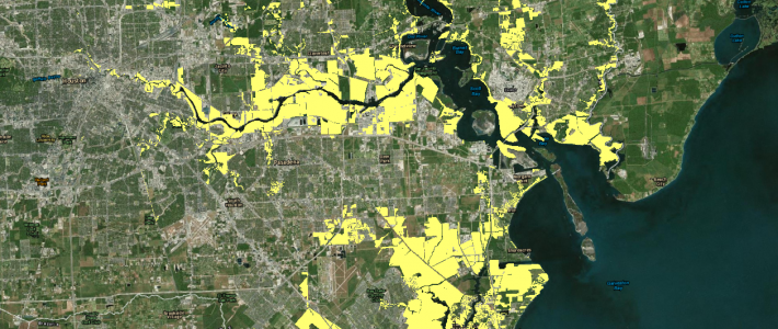
You might ask why is this relevant to me? The answer is because most areas protected by dams, levees and floodwalls are shown as X zones on FEMA flood maps. This means that the owners of most homes and buildings protected by dams, levees, and floodwalls do not maintain flood insurance and may not even be aware that their home or building is protected dam, levee or floodwall. Since so many dams, levees and floodwalls have not been properly maintained, or may be following outdated flood control manuals, you most likely have clients with substantial uninsured flood risk.

Last year was the first year that more than two inland flood events caused losses exceeding $1 billion each. Hurricane Matthew in October and Louisiana flooding in August topped $10 billion each, Houston flooding in April caused losses estimated at $2.7 billion, Sabine River Basin flood in East Texas and Louisiana in March were $1.3 billion, and West Virginia flash and riverine flooding in June topped $1 billion. Interestingly, most of these flood events occurred in X zones.

What’s interesting about Louisiana flash flood in August is that the storm causing the flooding was not even a tropical depression, but the lowest level a tropical system there can be. Yet, more than 10 rivers had reached record levels. It is estimated that nearly one-third of all homes (approximately 15,000 structures) in Ascension Parish were flooded after a levee along the Amite River was overtopped. With an estimated 146,000 structures damaged in the flooding, it was characterized as the worst US natural disaster since Hurricane Sandy in 2012.

Last year, the average annual precipitation in the 48 contiguous states was almost two inches higher than the long-term average. We believe that the recent trend of greater precipitation and a higher number of catastrophic flood events in X zones will continue in the future.

If you are thinking that this is a recipe for disaster, you are correct. We encourage you to be proactive and take steps to identify those homes and buildings owned by your clients that are at much higher flood risk than the FEMA’s flood map portrays. Do not wait for a catastrophic event to impact your clients and your agency. Contact us today to learn how we can help you identify those homes and buildings that may be at a higher risk than you or your insured think. We will provide the information you need to implement a targeted flood insurance sales campaign to the right clients.

New FEMA Flood Maps for Harris County, TX

New FEMA flood maps take effect January 6, 2016 for Harris County, Texas. The new FEMA flood maps negatively impact more than 14,000 properties by placing either the entire property or a portion of the property into a Special Flood Hazard Area (SFHA: A and V Zones) for the first time. This means new flood insurance requirements for thousands of property owners in Harris County.

If you have clients that own and/or manage properties in Harris County that presently are not in the SFHA, call us to discuss how our unique Flood Zone Determination Service can identify which, if any, of your client’s properties will be placed in the SFHA by the new FEMA flood maps. We will help you minimize your errors and omission exposure while reducing the risk of your clients suffering uninsured or under-insured flood losses.

AFR Introduces Flood Zone Determination Service

Agency Flood Resources (AFR) is proud to announce the launch of an innovative and superior flood zone determination service that is designed to deliver results that are more accurate and more timely than the results of other flood zone determination providers. Our unique service is far more likely to prevent uninsured flood losses and enhance timely decision making, by solving many of the problems that are inherent to conventional flood zone determination processes.

The current industry standards are for lenders to run annual determinations on the anniversary of their initial determination and for insurance agents to, at best, run annual determinations as they approach each property insurance renewal. Both of these industry standards fail to identify map changes that occur in between the annual determinations and they fail to deliver results before a new flood map takes effect. These deficiencies leave most property owners susceptible to substantial uninsured flood losses and unexpected increases to their budget, while insurance agents susceptible to substantial errors and omissions exposure. Our innovative flood zone determination service is designed to notify you of forthcoming flood map changes in real-time prior to a new flood map taking effect, which greatly reduces the risk of your clients suffering uninsured flood losses and unexpected budget increases and, therefore, minimizes your errors and omissions exposure.

The current industry standard is for determinations to be based solely on geocode data and generated by systems that are completely automated, which increase the probability of error. Our proprietary process begins with Certified Floodplain Managers using property appraiser data to manually identify the correct parcel and then plot the parcel boundary and the footprint of each building to ensure accurate results.

The current industry standard is to base a determination on one pin point that is placed either at the mid-point of the boundary line adjoining the street or in the center of the parcel. Both of these processes are prone to error for large parcels or parcels with multiple buildings because they often span multiple flood zones. Our process ensures accurate results for every building regardless of the size of the property or the number of buildings on the property.

The current industry standard is to deliver a standard flood hazard determination form for each street address, which is an inefficient format for results for companies with sizable portfolios. Our system delivers a flood zone determination report in an Excel spreadsheet format, which makes it easy and quick to analyze results and to incorporate results in your client’s schedule of values.

Why reply on outdated technology and processes when, for about the cost, you can leverage our state-of-the-art technology platform and innovative process to monitor flood zone changes for your client’s entire portfolio in real-time.


Contact us to learn how our innovative flood zone determination service will minimize your errors and omission exposure while reducing the risk of your clients suffering uninsured flood losses.

Contact Us

Get in Touch

Toll Free: (844) 359-7468
Phone: (561) 253-9020

Email Us